
") BuriedHomes
BuriedHomes At nearly 1,000 years young, Sunset Crater volcano is a geological infant, the latest development ...") One Volcano Amid Many
One Volcano Amid Many At nearly 1,000 years young, Sunset Crater volcano is a geological infant, the latest development in a series of eruptions that have taken place here over the past 6 million years. It is only a small part of the impressive San Francisco Volcanic field of northern Arizona.
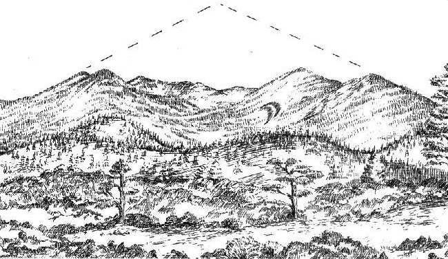
From this point, three different types of volcanoes are visible. What makes a volcano tall or short, steep or gentle, or an eruption more or less violent? Mostly the magma’s stickiness or viscosity, which is determined by its chemical composition and gas content.
At nearly 1,000 years young, Sunset Crater volcano is a geological infant, the latest development in a series of eruptions that have taken place here over the past 6 million years. It is only a small part of the impressive San Francisco Volcanic field of northern Arizona.
From this point, three different types of volcanoes are visible. What makes a volcano tall or short, steep or gentle, or an eruption more or less violent? Mostly the magma’s stickiness or viscosity, which is determined by its chemical composition and gas content.
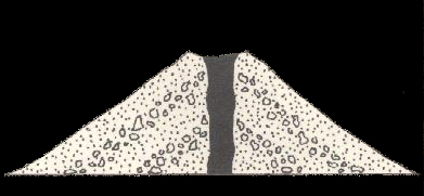 Cinder cones, like Sunset crater and most of the 6000 or so volcanoes in this field, tend to be cone shaped with sides not steeper than 33 degrees. A cinder cone is literally a pile of loose fragments. It is easily eroded and will change shape, becoming less steep as it ages.
 Look for a dome volcano (O’Leary Peak) on the horizon in front of you.
Dome volcanoes tend to h...") O'Leary Peak
O'Leary Peak
Look for a dome volcano (O’Leary Peak) on the horizon in front of you. Dome volcanoes tend to have steep sides and rounded shape.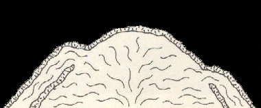
 On the horizon, the San Francisco Peaks rise as the highest mountains, forming the dominant feature...") An Explosive Past?
An Explosive Past? On the horizon, the San Francisco Peaks rise as the highest mountains, forming the dominant feature of the san Francisco Volcanic Field. Imagine the sides continuing up to form one 16,000-foot-high mountain. This may be what the stratovolcano looked like about 500,000 years ago. The summit and flank of the volcano may have exploded and collapsed, much like Mount St. Helens. Erosion over thousands of years has created several peaks from the original volcano. Humphreys Peak, standing at 12,633 feet, is the tallest and is the highest peak in Arizona.
How did they get their name? The peaks were named in 1629 by a group of Franciscan missionaries in honor of St. Francis of Assisi. In 1847, a small West Coast settlement on the verge of becoming a boom-town changed its name from Yerba Buena to San Francisco. This happened more than 300 years after the Arizona peaks were christened.
On the horizon, the San Francisco Peaks rise as the highest mountains, forming the dominant feature of the san Francisco Volcanic Field. Imagine the sides continuing up to form one 16,000-foot-high mountain. This may be what the stratovolcano looked like about 500,000 years ago. The summit and flank of the volcano may have exploded and collapsed, much like Mount St. Helens. Erosion over thousands of years has created several peaks from the original volcano. Humphreys Peak, standing at 12,633 feet, is the tallest and is the highest peak in Arizona.
How did they get their name? The peaks were named in 1629 by a group of Franciscan missionaries in honor of St. Francis of Assisi. In 1847, a small West Coast settlement on the verge of becoming a boom-town changed its name from Yerba Buena to San Francisco. This happened more than 300 years after the Arizona peaks were christened.
") Hornito
Hornito
 Looking beyond the lava and spatter in front of you, and just beyond the line of trees, can you see...") Surface Currents
Surface Currents Looking beyond the lava and spatter in front of you, and just beyond the line of trees, can you see a reddish hill? This is an agglutinate mound or pile of welded pyroclastic material.
In the early stages of the eruption, a cone began to form next to a major explosive vent. The cone became armored by welded deposits. Then a column of dense magma broke through the base of the cone, causing the upper part of the cone to collapse onto the top of the flow. The slumped pieces were then rafted away by the flowing lava. You are looking at a large piece of an early-stage cone of Sunset Crater.
Perhaps within weeks or days after breaching, the cone was rebuilt, creating the symmetrical cone of Sunset Crater we see today. Any remnants of the earlier cone lie buried beneath tons of cinder.
Looking beyond the lava and spatter in front of you, and just beyond the line of trees, can you see a reddish hill? This is an agglutinate mound or pile of welded pyroclastic material.
In the early stages of the eruption, a cone began to form next to a major explosive vent. The cone became armored by welded deposits. Then a column of dense magma broke through the base of the cone, causing the upper part of the cone to collapse onto the top of the flow. The slumped pieces were then rafted away by the flowing lava. You are looking at a large piece of an early-stage cone of Sunset Crater.
Perhaps within weeks or days after breaching, the cone was rebuilt, creating the symmetrical cone of Sunset Crater we see today. Any remnants of the earlier cone lie buried beneath tons of cinder.
 Patterns often reveal forces otherwise invisible to us. As you cross the bridge, look to your right ...") Xenolith
Xenolith
Patterns often reveal forces otherwise invisible to us. As you cross the bridge, look to your right for a small light-colored rock embedded in the dark basalt rock. This is a xenolith (zee-no-lith), a rock fragment foreign to the body of rock in which it occurs. When magma rose to the surface, it brought up pieces of limestone from 700 to 1,000 feet below us. Uplift and erosion have exposed this rock (known as Kaibab limestone) elsewhere: at the rims of Grand Canyon and nearby Walnut Canyon and in cliffs at Wupatki National Monument. Alpine slopes, forests, and grassy parks disguise the fiery, molten, and often explosive history of...") Our Dynamic Earth
Our Dynamic Earth Alpine slopes, forests, and grassy parks disguise the fiery, molten, and often explosive history of this region’s landscape. But here, amidst the Bonito Lava Flow and Sunset Crater’s cinder fields, the land’s volcanic origin is revealed in stunning clarity.
As you walk the trail, use this guide to explore the powerful forces – rapid and violent, slow and patient – that continually shape our planet. These forces all affect our lives and provide for life in ways we may not realize.
Alpine slopes, forests, and grassy parks disguise the fiery, molten, and often explosive history of this region’s landscape. But here, amidst the Bonito Lava Flow and Sunset Crater’s cinder fields, the land’s volcanic origin is revealed in stunning clarity.
As you walk the trail, use this guide to explore the powerful forces – rapid and violent, slow and patient – that continually shape our planet. These forces all affect our lives and provide for life in ways we may not realize.
 Sunset Crater rises before you, a nearly symmetrical cone. Its perfect shape suggests a simple erup...") A Complicated History
A Complicated History Sunset Crater rises before you, a nearly symmetrical cone. Its perfect shape suggests a simple eruption history, but that was not the case. In fact, it wasn't until the 1980s that scientists began to understand the complexity and extent of the eruption.
First, molten rock (magma) and gasses pushed up to the earth’s surface along a six-mile-long weak spot or fissure in the earth’s crust. Volcanic fragments, called pyroclasts, shot upward along the fissure in a “curtain of fire” as gasses escaped violently. Small cinder cones formed along this fissure before the magma became focuses and erupted as a lava fountain from a primary vent. A large cone (Sunset Crater) grew as the shower of cinders and ash piled up around the vent.
Sunset Crater rises before you, a nearly symmetrical cone. Its perfect shape suggests a simple eruption history, but that was not the case. In fact, it wasn't until the 1980s that scientists began to understand the complexity and extent of the eruption.
First, molten rock (magma) and gasses pushed up to the earth’s surface along a six-mile-long weak spot or fissure in the earth’s crust. Volcanic fragments, called pyroclasts, shot upward along the fissure in a “curtain of fire” as gasses escaped violently. Small cinder cones formed along this fissure before the magma became focuses and erupted as a lava fountain from a primary vent. A large cone (Sunset Crater) grew as the shower of cinders and ash piled up around the vent. You are now on the southern edge of the Bonito Lava Flow. Magma, periodically relieved of gas press...") Ropes and Clinkers
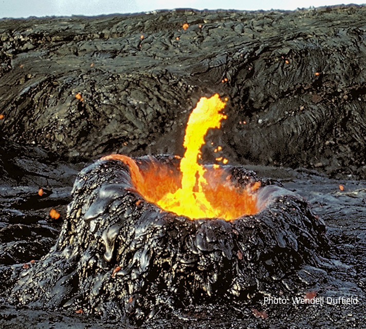
Ropes and Clinkers You are now on the southern edge of the Bonito Lava Flow. Magma, periodically relieved of gas pressure, squeezed out of the base of the cone as glowing liquid lava, creating a structurally complex flow covering 2 sq miles (5 sq km).
Lava flows tend to form either jagged blocks, known as aa (ah-ah), or a smooth, ropey surface of pahoehoe (pa-hoy-hoy). Flows usually start as pahoehoe, thin and runny. As the lava cools and becomes more thick and pasty, it can change into an aa flow. The Bonito Flow is mostly aa lava. When aa is forming, cooled, hardened blocks - sometimes called clinkers - are rafted along the surface of moving lava, making clinking noises as they tumble into each other.
Although its structure is complicated, the flow’s composition is uniform throughout. The lava and cinders around you, whether black or red, ropey or jagged, are basalt.
You are now on the southern edge of the Bonito Lava Flow. Magma, periodically relieved of gas pressure, squeezed out of the base of the cone as glowing liquid lava, creating a structurally complex flow covering 2 sq miles (5 sq km).
Lava flows tend to form either jagged blocks, known as aa (ah-ah), or a smooth, ropey surface of pahoehoe (pa-hoy-hoy). Flows usually start as pahoehoe, thin and runny. As the lava cools and becomes more thick and pasty, it can change into an aa flow. The Bonito Flow is mostly aa lava. When aa is forming, cooled, hardened blocks - sometimes called clinkers - are rafted along the surface of moving lava, making clinking noises as they tumble into each other.
Although its structure is complicated, the flow’s composition is uniform throughout. The lava and cinders around you, whether black or red, ropey or jagged, are basalt. Most volcanoes are found along tectonic plate boundaries where continents and seafloors collide or ...") Why are Volcanoes Here?
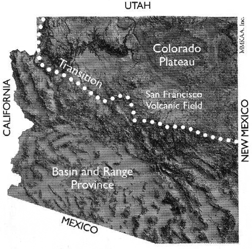
Why are Volcanoes Here? Most volcanoes are found along tectonic plate boundaries where continents and seafloors collide or move apart. We are far from a plate boundary; consequently, geologists debate why volcanoes occur here. One theory proposes that the North American plate is moving over a stationary “hot spot.” But this theory does not explain why there are young volcanic fields all along the southern margin of the Colorado Plateau and then east to New Mexico and Oklahoma.
Another more accepted theory focuses on a disruption in the flow of Earth’s mantle at the boundary between the Colorado Plateau, where the Earth’s crust is very thick, and the Basin and Range region (to the south and west), where the crust is very thin. At this transition, heat from the mantle rises and melting occurs. Ancient faults, activated by stretching of the North American plate (which has created the Basin and range and is extending into the Colorado Plateau), serve as pathways for magma to move to the surface.
Most volcanoes are found along tectonic plate boundaries where continents and seafloors collide or move apart. We are far from a plate boundary; consequently, geologists debate why volcanoes occur here. One theory proposes that the North American plate is moving over a stationary “hot spot.” But this theory does not explain why there are young volcanic fields all along the southern margin of the Colorado Plateau and then east to New Mexico and Oklahoma.
Another more accepted theory focuses on a disruption in the flow of Earth’s mantle at the boundary between the Colorado Plateau, where the Earth’s crust is very thick, and the Basin and Range region (to the south and west), where the crust is very thin. At this transition, heat from the mantle rises and melting occurs. Ancient faults, activated by stretching of the North American plate (which has created the Basin and range and is extending into the Colorado Plateau), serve as pathways for magma to move to the surface.
 When the lava flowed and the cinder cone formed, all plant life within a several mile radius was de...") Taking Root
Taking Root When the lava flowed and the cinder cone formed, all plant life within a several mile radius was destroyed. The oldest ponderosa pine trees here today are about 400 years old and are probably not the first generation to return. Unlike Hawaii where abundant moisture promotes plant growth soon after eruptions, precipitation here averages only 16 inches (41 cm) a year. Furthermore, soil is sparse in this dry climate where water limits plant life and organic material breaks down slowly.
Notice the massive trailing root system of this dead tree. Trees growing on these cinder slopes face extraordinary challenges in finding anchor in loose, unstable cinders and in capturing water as it drains rapidly through them. Notice also how this tree spiraled as it grew. Ponderosa pines grow either straight or dextrally (spiraling to the right). Spiral growth reduces the overall strength of a tree but increases its flexibility. The spiral grain also provides an even distribution of water from a single root to all of the needles and of nutrients from a single branch to all the roots. In a straight tree, wind-damaged branches or damaged roots would deprive water and nutrients to the roots directly below and branches directly above. By spiraling, this tree was better adapted to the stresses of its environment: lack of water, high winds, and occasional heavy snow. But it wasn't able to remain anchored when its roots were exposed by erosion from foot traffic.
When the lava flowed and the cinder cone formed, all plant life within a several mile radius was destroyed. The oldest ponderosa pine trees here today are about 400 years old and are probably not the first generation to return. Unlike Hawaii where abundant moisture promotes plant growth soon after eruptions, precipitation here averages only 16 inches (41 cm) a year. Furthermore, soil is sparse in this dry climate where water limits plant life and organic material breaks down slowly.
Notice the massive trailing root system of this dead tree. Trees growing on these cinder slopes face extraordinary challenges in finding anchor in loose, unstable cinders and in capturing water as it drains rapidly through them. Notice also how this tree spiraled as it grew. Ponderosa pines grow either straight or dextrally (spiraling to the right). Spiral growth reduces the overall strength of a tree but increases its flexibility. The spiral grain also provides an even distribution of water from a single root to all of the needles and of nutrients from a single branch to all the roots. In a straight tree, wind-damaged branches or damaged roots would deprive water and nutrients to the roots directly below and branches directly above. By spiraling, this tree was better adapted to the stresses of its environment: lack of water, high winds, and occasional heavy snow. But it wasn't able to remain anchored when its roots were exposed by erosion from foot traffic. On the slope below you is a small spatter cone. Spatter cones, or hornitos (“little ovens” in S...") Miniature Volcanoes
Miniature Volcanoes On the slope below you is a small spatter cone. Spatter cones, or hornitos (“little ovens” in Spanish), form when lava is forced up through an opening in the cooled surface of a lava flow. They are “rootless,” fed by the underlying flow rather than a deep magma conduit. Can you picture fluid fragments of liquid spurting upward, flattening, congealing, and mounding around the opening?
 Can you imagine approaching an erupting spatter cone? Unique artifacts found nearby – corn casts in lava rock – suggest people did. Experiments conducted in Hawaii demonstrated that “corn rocks,” like the one on display in the visitor center, can form when ears of corn are covered by fluid blobs of spatter. It appears people intentionally ventured close to an active hornito, maybe this one, to leave corn – perhaps as an offering. More than 50 rocks with corn casts have been found in homesites attributed to the local Sinagua cultural tradition.
 Beneath the lava you now stand on are perhaps dozens of caves. As lava flowed, the top surface cool...") Undercurrents
Undercurrents Beneath the lava you now stand on are perhaps dozens of caves. As lava flowed, the top surface cooled first due to contact with air. A hardened crust formed. Meanwhile, rivers of lava continued flowing below, periodically breaking through the crust to form the spatter cones you saw earlier. When the flows ceased, the remaining lava drained out the downhill end of the crusted-over channels, leaving behind tube-like caves.
Most of these caves were sealed with hardened lava and have no openings to the surface. A collapse created the opening you see here.
Beneath the lava you now stand on are perhaps dozens of caves. As lava flowed, the top surface cooled first due to contact with air. A hardened crust formed. Meanwhile, rivers of lava continued flowing below, periodically breaking through the crust to form the spatter cones you saw earlier. When the flows ceased, the remaining lava drained out the downhill end of the crusted-over channels, leaving behind tube-like caves.
Most of these caves were sealed with hardened lava and have no openings to the surface. A collapse created the opening you see here.

") Debate
Debate