Home / Keyword virtual trail 56


A curious place to build a farming community...summers are hot, dry and windy. Yet 800 years ago,...") Living and Storage Rooms
Living and Storage Rooms A curious place to build a farming community...summers are hot, dry and windy. Yet 800 years ago, agricultural plots would have dotted the landscape, carefully placed in scant pockets of soil.
A farmer's faith was tested regularly as rainfall came at the wrong time or not at all, and dry winds parched the soil and crops. Each field was at the mercy of where rain fell; no surface irrigation was possible. One field might produce while another withered, so the planting effort was extensive.
Then, as now, water was limited. Across the area, a few seeps and springs existed; catchments held water for a time, and the Little Colorado River provided a seasonal water source.
Still the abundance of storage pots suggests water had to be acquired and managed to be available when needed. Perhaps, as Hopi believe, people derived strength from this challenging land.
A curious place to build a farming community...summers are hot, dry and windy. Yet 800 years ago, agricultural plots would have dotted the landscape, carefully placed in scant pockets of soil.
A farmer's faith was tested regularly as rainfall came at the wrong time or not at all, and dry winds parched the soil and crops. Each field was at the mercy of where rain fell; no surface irrigation was possible. One field might produce while another withered, so the planting effort was extensive.
Then, as now, water was limited. Across the area, a few seeps and springs existed; catchments held water for a time, and the Little Colorado River provided a seasonal water source.
Still the abundance of storage pots suggests water had to be acquired and managed to be available when needed. Perhaps, as Hopi believe, people derived strength from this challenging land.
The black cinders blanketing the ground remain from the eruption of nearby Sunset Crater volcano s...") Sunset Crater and Wupatki
Sunset Crater and Wupatki The black cinders blanketing the ground remain from the eruption of nearby Sunset Crater volcano some time between 1040 and 1100. The settlement of Wupatki followed but it's uncertain if there was a direct cause and effect.
People may have been drawn by the eruption and stayed. Or, perhaps those displaced by the eruption moved to this lower elevation. However, as many as three generations may have passed before anyone decided to live here.
We do know that ash from the eruption, in a thin uniform layer, retained precious soil moisture providing a window of improved farming potential in this semi-arid landscape.
The black cinders blanketing the ground remain from the eruption of nearby Sunset Crater volcano some time between 1040 and 1100. The settlement of Wupatki followed but it's uncertain if there was a direct cause and effect.
People may have been drawn by the eruption and stayed. Or, perhaps those displaced by the eruption moved to this lower elevation. However, as many as three generations may have passed before anyone decided to live here.
We do know that ash from the eruption, in a thin uniform layer, retained precious soil moisture providing a window of improved farming potential in this semi-arid landscape.
Compare the images above. The rooms now visible were buried beneath rubble cleared during excavat...") Wupatki Pueblo 1930s vs. 2011
Wupatki Pueblo 1930s vs. 2011 Compare the images above. The rooms now visible were buried beneath rubble cleared during excavation beginning in 1933.
When occupied, this mud and stone building would have required periodic maintenance. Once people departed, natural forces prevailed - mortar eroded, roofs collapsed, walls tumbled. What you see today is an excavated building, heavily stabilized to postpone deterioration. The modern iron beam and plate visible here support the upper walls. The low walls exhibit Portland cement, used from the 1930s to 60s, and new stabilization mortars that more closely duplicate original materials. Although walls stand in their original location, virtually all the mortar you see is modern. Stabilization has compromised the historical architecture, but helps an excavated building withstand natural and human-induced erosion.
You are one of hundreds of thousands of visitors - please, do not lean, sit, or walk on any walls.
Numerous storage rooms within the pueblo attest to a constant preparedness for crop failure. Peop...") Storage and Food Processing
Storage and Food Processing Numerous storage rooms within the pueblo attest to a constant preparedness for crop failure. People likely had some of last year's corn on hand at this year's harvest. Perhaps this room served for storage and food processing.
Imagine corn stacked like cordwood, or gathered foods such as piñon nuts, rice grass seeds, and juniper berries secured in clay seed jars. Water jars undoubtedly sat here too. Hours spent at these grinding stones reduced corn and seeds to flour.
Numerous storage rooms within the pueblo attest to a constant preparedness for crop failure. People likely had some of last year's corn on hand at this year's harvest. Perhaps this room served for storage and food processing.
Imagine corn stacked like cordwood, or gathered foods such as piñon nuts, rice grass seeds, and juniper berries secured in clay seed jars. Water jars undoubtedly sat here too. Hours spent at these grinding stones reduced corn and seeds to flour.
In this room, someone designed an innovative air circulation system to allow for an indoor fire. A...") Air Circulation System
Air Circulation System In this room, someone designed an innovative air circulation system to allow for an indoor fire. A stone-lined ventilator trench is connected to an opening in the base of the cliff wall.
The upright stone slab at the end of the ventilator trench deflected incoming air so that the draft would pass directly across the firepit. Smoke would exit through a roof opening.
Note how preservation efforts have changed this building: original floor surface, as with this room, are much lower - dirt placed in the rooms after excavation protects floor features and keeps walls from collapsing.
Throughout the dwelling you'll see a variety of modern drains that keep water from standing in rooms. In some cases the architecture has been altered. For example, the square and round holes on this front wall were placed for drainage, and the large masonry column built in the back corner supports the upper wall.
In this room, someone designed an innovative air circulation system to allow for an indoor fire. A stone-lined ventilator trench is connected to an opening in the base of the cliff wall.
The upright stone slab at the end of the ventilator trench deflected incoming air so that the draft would pass directly across the firepit. Smoke would exit through a roof opening.
Note how preservation efforts have changed this building: original floor surface, as with this room, are much lower - dirt placed in the rooms after excavation protects floor features and keeps walls from collapsing.
Throughout the dwelling you'll see a variety of modern drains that keep water from standing in rooms. In some cases the architecture has been altered. For example, the square and round holes on this front wall were placed for drainage, and the large masonry column built in the back corner supports the upper wall.
This section of the pueblo remains unexcavated. These rooms represent an opportunity to learn mor...") Unexcavated Rooms
Unexcavated Rooms This section of the pueblo remains unexcavated. These rooms represent an opportunity to learn more about the past, but the knowledge comes at a cost. Excavation disturbs the site, and potentially, the people and artifacts buried there. Collected materials require elaborate conservation and storage methods; in the ground, this arid climate preserves artifacts almost indefinitely, free of charge.
In the past, few people challenged the purposes of archaeological investigation, but today many voice concerns about disturbing sites. Should rooms be excavated, unearthing pots and other items? Possessions were intended, by those who buried or left them behind, to remain as placed, acted upon by time and the elements. Excavation represents a curiosity foreign to American Indian culture and often considered culturally offensive. Do objects from the past serve as legitimate educational tools, or is that notion unimportant or even wrong?
This section of the pueblo remains unexcavated. These rooms represent an opportunity to learn more about the past, but the knowledge comes at a cost. Excavation disturbs the site, and potentially, the people and artifacts buried there. Collected materials require elaborate conservation and storage methods; in the ground, this arid climate preserves artifacts almost indefinitely, free of charge.
In the past, few people challenged the purposes of archaeological investigation, but today many voice concerns about disturbing sites. Should rooms be excavated, unearthing pots and other items? Possessions were intended, by those who buried or left them behind, to remain as placed, acted upon by time and the elements. Excavation represents a curiosity foreign to American Indian culture and often considered culturally offensive. Do objects from the past serve as legitimate educational tools, or is that notion unimportant or even wrong?
The reconstructed circular structure below you resembles a great kiva, a special room used for rit...") Community Room
Community Room The reconstructed circular structure below you resembles a great kiva, a special room used for rituals and ceremonies. However, excavators found no evidence of a roof or other floor features typical of a kiva. Archeologists speculate that this open-air community room could have served as a central gathering place. Imagine voices carrying to others assembled on the pueblo roof tops.
People may have come from nearby and distant villages to participate in ceremonies held here. Maybe rituals focused the community and solved problems, or served to redistribute materials and food.
The reconstructed circular structure below you resembles a great kiva, a special room used for rituals and ceremonies. However, excavators found no evidence of a roof or other floor features typical of a kiva. Archeologists speculate that this open-air community room could have served as a central gathering place. Imagine voices carrying to others assembled on the pueblo roof tops.
People may have come from nearby and distant villages to participate in ceremonies held here. Maybe rituals focused the community and solved problems, or served to redistribute materials and food. This depiction of a ball game is based on descriptions of games played by the Mayan and Aztec cultur...") Ballcourt Interpretative Panel
Ballcourt Interpretative Panel
This depiction of a ball game is based on descriptions of games played by the Mayan and Aztec cultures of Mexico and speculations on the Hohokam games in southern Arizona.
Ballcourts were common in southern Arizona from A.D. 750 to 1200, but relatively rare here in the northern part of the state. This suggests that the people of Wupatki intermingled within their southern Arizona neighbors – the Hohokam – who may have borrowed and modified the ballcourt idea from earlier contact with the Indian cultures of Mexico. Located along major natural drainages and travel routes, ballcourts may have provided opportunities for social exchange between villages. They were often within a one-day walk of a neighboring village. There is continued speculation about the uses of the ballcourts. Because of the work involved in building a ballcourt and the numbers that have been found (over 200 in Arizona), ball games may have been an important part of life for the people of Wupatki and their southern neighbors. The Hohokam balls – found at archaeological sites containing ballcourts – were made of carefully shaped rock and perhaps covered with pin pitch or other material. One form of the game might have involved moving the ball toward a goal using a curved stick.
The Wupatki ballcourt is 78 feet wide, 102 feet long, and had a 6-foot-high wall. Excavated and stabilized in 1965, a large part of the interior wall has been reconstructed. This intriguing geological feature was unearthed during the 1965 excavations of the Wupatki Ballcour...") The Blowhole
The Blowhole
This intriguing geological feature was unearthed during the 1965 excavations of the Wupatki Ballcourt. After its discovery, the National Park Service bricked in the opening, giving the blowhole the appearance it has today and allowing visitors the experience of feeling the rush of air from the opening. It is unknown if the people of Wupatki were aware of the blowhole, and if they were, what significance the feature may have held to prehistoric people. This blowhole – a crevice in the earth’s crust that appears to breathe – is one of several fou...") The Blowhole Interpretative Panel
The Blowhole Interpretative Panel
This blowhole – a crevice in the earth’s crust that appears to breathe – is one of several found in the Wupatki area. It connects to an underground passage – size, depth, and complexity unknown – called an earthcrack. Earthcracks resulted from earthquake activity in the Kaibab Limestone bedrock and have enlarged over time. Archaeologists have yet to uncover any evidence of prehistoric structures or uses at the blowhole. Its connection to the Wupatki Pueblo remains a mystery. Today, the Hopi descendants of these early people, refer to the blowhole as the breath of “Yaapontsa,” the wind spirit. They and other American Indians attach a spiritual significance to these features. Length: 1/2 mile (0.8 km) round trip.
Time required: 45 minutes
Terrain: Paved with some steps a...") Introduction to the Trail
Introduction to the Trail
Length: 1/2 mile (0.8 km) round trip. Time required: 45 minutes Terrain: Paved with some steps and inclines. Wheelchair accessible to overlook, beyond with assistance.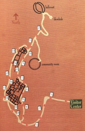
The farming settlement of Wupatki was unique. To appreciate why, we have to start by thinking big. From roughly 400 to 1700, culture in the Southwest was distinguished by farming, pottery, villages, seasonal moves, and large scale migrations. Major settlement systems were in place by 1100 in Chaco Canyon, the Phoenix Basin, and northern Mesoamerica. With favorable climates for agriculture and room to grow, the Southwest's farming population was reaching a peak. Until the mid-1100s, Wupatki remained a "frontier" between established groups, defined by archeologists as Sinagua, Cohonina, and Kayenta. Then, in one of the warmest, driest places on the Colorado Plateau, life flourished. This became a densely populated landscape supporting a complex society where people, goods, and ideas converged. Notice how people shaped their lives to this land. Sun, water, wind, and earth influenced decisions...") Terraced Rooms
Terraced Rooms
Notice how people shaped their lives to this land. Sun, water, wind, and earth influenced decisions. Using the red sandstone outcrop as a backbone, and its naturally fractured blocks as bricks, masons laid stone rooms up and down the length of the formation. High walls on the north and west sides blunted prevailing winds. Terraced rooms to the south and east bathed in winter sun. Flat roofs served as water systems, collecting precipitation and directing it to storage pots. Wupatki Pueblo stood three stories high in places. Double walls were filled with a rubble core and were about 6 feet (2 meters) high; roofs were constructed with timbers, cross-laid with smaller beams or reeds, and finished with grass and mud. There were no exterior doorways at ground level.
Built out in the open, Wupatki is far more typical of 12th century structures than a cliff dwelling. Cliff dwellings make up only a fraction of known southwestern archeological sites.
Wupatki Pueblo stood three stories high in places. Double walls were filled with a rubble core and were about 6 feet (2 meters) high; roofs were constructed with timbers, cross-laid with smaller beams or reeds, and finished with grass and mud. There were no exterior doorways at ground level.
Built out in the open, Wupatki is far more typical of 12th century structures than a cliff dwelling. Cliff dwellings make up only a fraction of known southwestern archeological sites.
"...The family, the dwelling house and the field are inseparable, because the woman is the heart of these, and they rest with her... The man builds the house but the woman is the owner, because she repairs and preserves it." -A Hopi view of the community, presented to "the Washington Chiefs," 1894 The ancestors of today’s Hopi and Zuni Indians witnessed the eruption.
In some Hopi accounts, t...") Traditions
Traditions
The ancestors of today’s Hopi and Zuni Indians witnessed the eruption. In some Hopi accounts, the Qa’na Katsina caused Palatsmo (Sunset Crater) to erupt after people engaged koyaanisqatsi, a life out of balance. For Hopi people, Palatsmo is a living reminder: if people stray from their religious ideals and lifeway, there may be another eruption. In Zuni traditions, stories of the eruption were carefully guarded because of the belief if people continually dwell upon negative events those events will happen.
Regardless of our worldview, places like Sunset Crater Volcano National Monument help us to better understand each other and the forces that continually affect our lives. Along the perimeter of the flow, a unique microhabitat for plants exists. In places, water collects ...") Penstemon
Penstemon
Along the perimeter of the flow, a unique microhabitat for plants exists. In places, water collects on the surface of the flow and is then channeled through fractures to the edge where it locally benefits plants. White-barked aspen trees grow around the perimeter of the flow and along fracture systems. In area of deep cinder, like the dunes in the distance to your left, specialized plants have evolved. The Sunset Crater penstemon evolved new traits which allow it to live on cinder soils but also make this endemic plant dependent on this habitat. It cannot survive elsewhere. At nearly 1,000 years young, Sunset Crater volcano is a geological infant, the latest development ...") One Volcano Amid Many
One Volcano Amid Many At nearly 1,000 years young, Sunset Crater volcano is a geological infant, the latest development in a series of eruptions that have taken place here over the past 6 million years. It is only a small part of the impressive San Francisco Volcanic field of northern Arizona.
From this point, three different types of volcanoes are visible. What makes a volcano tall or short, steep or gentle, or an eruption more or less violent? Mostly the magma’s stickiness or viscosity, which is determined by its chemical composition and gas content.
At nearly 1,000 years young, Sunset Crater volcano is a geological infant, the latest development in a series of eruptions that have taken place here over the past 6 million years. It is only a small part of the impressive San Francisco Volcanic field of northern Arizona.
From this point, three different types of volcanoes are visible. What makes a volcano tall or short, steep or gentle, or an eruption more or less violent? Mostly the magma’s stickiness or viscosity, which is determined by its chemical composition and gas content.
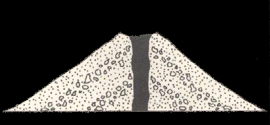 Cinder cones, like Sunset crater and most of the 6000 or so volcanoes in this field, tend to be cone shaped with sides not steeper than 33 degrees. A cinder cone is literally a pile of loose fragments. It is easily eroded and will change shape, becoming less steep as it ages.