Home / Keyword virtual trail 56

 Patterns often reveal forces otherwise invisible to us. As you cross the bridge, look to your right ...") Xenolith
Xenolith
Patterns often reveal forces otherwise invisible to us. As you cross the bridge, look to your right for a small light-colored rock embedded in the dark basalt rock. This is a xenolith (zee-no-lith), a rock fragment foreign to the body of rock in which it occurs. When magma rose to the surface, it brought up pieces of limestone from 700 to 1,000 feet below us. Uplift and erosion have exposed this rock (known as Kaibab limestone) elsewhere: at the rims of Grand Canyon and nearby Walnut Canyon and in cliffs at Wupatki National Monument.
\"For its time and place there was no other pueblo like Wupatki. It was in all probability the tal...") Wupatki Pueblo and Surrounding Features
Wupatki Pueblo and Surrounding Features "For its time and place there was no other pueblo like Wupatki. It was in all probability the tallest, largest, and perhaps the richest and most influential pueblo in the area."
-E. Brennan and C. Downum, from Report of Findings Prestabilization Documentation for Wupatki Pueblo
"For its time and place there was no other pueblo like Wupatki. It was in all probability the tallest, largest, and perhaps the richest and most influential pueblo in the area."
-E. Brennan and C. Downum, from Report of Findings Prestabilization Documentation for Wupatki Pueblo
People gathered here during the 1100s and what began as family housing grew into this 100-room pueblo with a tower, community room, and ceremonial ballcourt. Located near the crossroads of east-west and north-south travel routes, the pueblo evolved to serve a community heavily engaged not only in farming but also in ceremony, trade, and crafts specialization. By 1190, as many as 2,000 people lived within a day's walk and Wupatki Pueblo was the largest building for at least 50 miles. Archaeologists are challenged to define a cultural identity for Wupatki Pueblo with its intriguing blend of Kayenta and Sinagua architectural styles and more than 100 pottery types.
Compare the images above. The rooms now visible were buried beneath rubble cleared during excavat...") Wupatki Pueblo 1930s vs. 2011
Wupatki Pueblo 1930s vs. 2011 Compare the images above. The rooms now visible were buried beneath rubble cleared during excavation beginning in 1933.
When occupied, this mud and stone building would have required periodic maintenance. Once people departed, natural forces prevailed - mortar eroded, roofs collapsed, walls tumbled. What you see today is an excavated building, heavily stabilized to postpone deterioration. The modern iron beam and plate visible here support the upper walls. The low walls exhibit Portland cement, used from the 1930s to 60s, and new stabilization mortars that more closely duplicate original materials. Although walls stand in their original location, virtually all the mortar you see is modern. Stabilization has compromised the historical architecture, but helps an excavated building withstand natural and human-induced erosion.
You are one of hundreds of thousands of visitors - please, do not lean, sit, or walk on any walls. Most volcanoes are found along tectonic plate boundaries where continents and seafloors collide or ...") Why are Volcanoes Here?
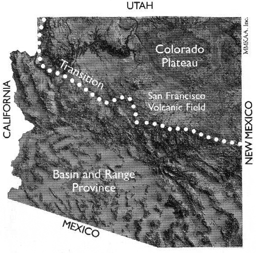
Why are Volcanoes Here? Most volcanoes are found along tectonic plate boundaries where continents and seafloors collide or move apart. We are far from a plate boundary; consequently, geologists debate why volcanoes occur here. One theory proposes that the North American plate is moving over a stationary “hot spot.” But this theory does not explain why there are young volcanic fields all along the southern margin of the Colorado Plateau and then east to New Mexico and Oklahoma.
Another more accepted theory focuses on a disruption in the flow of Earth’s mantle at the boundary between the Colorado Plateau, where the Earth’s crust is very thick, and the Basin and Range region (to the south and west), where the crust is very thin. At this transition, heat from the mantle rises and melting occurs. Ancient faults, activated by stretching of the North American plate (which has created the Basin and range and is extending into the Colorado Plateau), serve as pathways for magma to move to the surface.
Most volcanoes are found along tectonic plate boundaries where continents and seafloors collide or move apart. We are far from a plate boundary; consequently, geologists debate why volcanoes occur here. One theory proposes that the North American plate is moving over a stationary “hot spot.” But this theory does not explain why there are young volcanic fields all along the southern margin of the Colorado Plateau and then east to New Mexico and Oklahoma.
Another more accepted theory focuses on a disruption in the flow of Earth’s mantle at the boundary between the Colorado Plateau, where the Earth’s crust is very thick, and the Basin and Range region (to the south and west), where the crust is very thin. At this transition, heat from the mantle rises and melting occurs. Ancient faults, activated by stretching of the North American plate (which has created the Basin and range and is extending into the Colorado Plateau), serve as pathways for magma to move to the surface.
") Volcanoes
Volcanoes View from the inside of the \"ready-made\" room.") View from the Inside
View from the Inside
View from the inside of the "ready-made" room.
This section of the pueblo remains unexcavated. These rooms represent an opportunity to learn mor...") Unexcavated Rooms
Unexcavated Rooms This section of the pueblo remains unexcavated. These rooms represent an opportunity to learn more about the past, but the knowledge comes at a cost. Excavation disturbs the site, and potentially, the people and artifacts buried there. Collected materials require elaborate conservation and storage methods; in the ground, this arid climate preserves artifacts almost indefinitely, free of charge.
In the past, few people challenged the purposes of archaeological investigation, but today many voice concerns about disturbing sites. Should rooms be excavated, unearthing pots and other items? Possessions were intended, by those who buried or left them behind, to remain as placed, acted upon by time and the elements. Excavation represents a curiosity foreign to American Indian culture and often considered culturally offensive. Do objects from the past serve as legitimate educational tools, or is that notion unimportant or even wrong?
This section of the pueblo remains unexcavated. These rooms represent an opportunity to learn more about the past, but the knowledge comes at a cost. Excavation disturbs the site, and potentially, the people and artifacts buried there. Collected materials require elaborate conservation and storage methods; in the ground, this arid climate preserves artifacts almost indefinitely, free of charge.
In the past, few people challenged the purposes of archaeological investigation, but today many voice concerns about disturbing sites. Should rooms be excavated, unearthing pots and other items? Possessions were intended, by those who buried or left them behind, to remain as placed, acted upon by time and the elements. Excavation represents a curiosity foreign to American Indian culture and often considered culturally offensive. Do objects from the past serve as legitimate educational tools, or is that notion unimportant or even wrong? Beneath the lava you now stand on are perhaps dozens of caves. As lava flowed, the top surface cool...") Undercurrents
Undercurrents Beneath the lava you now stand on are perhaps dozens of caves. As lava flowed, the top surface cooled first due to contact with air. A hardened crust formed. Meanwhile, rivers of lava continued flowing below, periodically breaking through the crust to form the spatter cones you saw earlier. When the flows ceased, the remaining lava drained out the downhill end of the crusted-over channels, leaving behind tube-like caves.
Most of these caves were sealed with hardened lava and have no openings to the surface. A collapse created the opening you see here.
Beneath the lava you now stand on are perhaps dozens of caves. As lava flowed, the top surface cooled first due to contact with air. A hardened crust formed. Meanwhile, rivers of lava continued flowing below, periodically breaking through the crust to form the spatter cones you saw earlier. When the flows ceased, the remaining lava drained out the downhill end of the crusted-over channels, leaving behind tube-like caves.
Most of these caves were sealed with hardened lava and have no openings to the surface. A collapse created the opening you see here.

 The ancestors of today’s Hopi and Zuni Indians witnessed the eruption.
In some Hopi accounts, t...") Traditions
Traditions
The ancestors of today’s Hopi and Zuni Indians witnessed the eruption. In some Hopi accounts, the Qa’na Katsina caused Palatsmo (Sunset Crater) to erupt after people engaged koyaanisqatsi, a life out of balance. For Hopi people, Palatsmo is a living reminder: if people stray from their religious ideals and lifeway, there may be another eruption. In Zuni traditions, stories of the eruption were carefully guarded because of the belief if people continually dwell upon negative events those events will happen.
Regardless of our worldview, places like Sunset Crater Volcano National Monument help us to better understand each other and the forces that continually affect our lives. This blowhole – a crevice in the earth’s crust that appears to breathe – is one of several fou...") The Blowhole Interpretative Panel
The Blowhole Interpretative Panel
This blowhole – a crevice in the earth’s crust that appears to breathe – is one of several found in the Wupatki area. It connects to an underground passage – size, depth, and complexity unknown – called an earthcrack. Earthcracks resulted from earthquake activity in the Kaibab Limestone bedrock and have enlarged over time. Archaeologists have yet to uncover any evidence of prehistoric structures or uses at the blowhole. Its connection to the Wupatki Pueblo remains a mystery. Today, the Hopi descendants of these early people, refer to the blowhole as the breath of “Yaapontsa,” the wind spirit. They and other American Indians attach a spiritual significance to these features. This intriguing geological feature was unearthed during the 1965 excavations of the Wupatki Ballcour...") The Blowhole
The Blowhole
This intriguing geological feature was unearthed during the 1965 excavations of the Wupatki Ballcourt. After its discovery, the National Park Service bricked in the opening, giving the blowhole the appearance it has today and allowing visitors the experience of feeling the rush of air from the opening. It is unknown if the people of Wupatki were aware of the blowhole, and if they were, what significance the feature may have held to prehistoric people.") The Birth of a Mountain
The Birth of a Mountain Notice how people shaped their lives to this land. Sun, water, wind, and earth influenced decisions...") Terraced Rooms
Terraced Rooms
Notice how people shaped their lives to this land. Sun, water, wind, and earth influenced decisions. Using the red sandstone outcrop as a backbone, and its naturally fractured blocks as bricks, masons laid stone rooms up and down the length of the formation. High walls on the north and west sides blunted prevailing winds. Terraced rooms to the south and east bathed in winter sun. Flat roofs served as water systems, collecting precipitation and directing it to storage pots. Wupatki Pueblo stood three stories high in places. Double walls were filled with a rubble core and were about 6 feet (2 meters) high; roofs were constructed with timbers, cross-laid with smaller beams or reeds, and finished with grass and mud. There were no exterior doorways at ground level.
Built out in the open, Wupatki is far more typical of 12th century structures than a cliff dwelling. Cliff dwellings make up only a fraction of known southwestern archeological sites.
Wupatki Pueblo stood three stories high in places. Double walls were filled with a rubble core and were about 6 feet (2 meters) high; roofs were constructed with timbers, cross-laid with smaller beams or reeds, and finished with grass and mud. There were no exterior doorways at ground level.
Built out in the open, Wupatki is far more typical of 12th century structures than a cliff dwelling. Cliff dwellings make up only a fraction of known southwestern archeological sites.
"...The family, the dwelling house and the field are inseparable, because the woman is the heart of these, and they rest with her... The man builds the house but the woman is the owner, because she repairs and preserves it." -A Hopi view of the community, presented to "the Washington Chiefs," 1894 When the lava flowed and the cinder cone formed, all plant life within a several mile radius was de...") Taking Root
Taking Root When the lava flowed and the cinder cone formed, all plant life within a several mile radius was destroyed. The oldest ponderosa pine trees here today are about 400 years old and are probably not the first generation to return. Unlike Hawaii where abundant moisture promotes plant growth soon after eruptions, precipitation here averages only 16 inches (41 cm) a year. Furthermore, soil is sparse in this dry climate where water limits plant life and organic material breaks down slowly.
Notice the massive trailing root system of this dead tree. Trees growing on these cinder slopes face extraordinary challenges in finding anchor in loose, unstable cinders and in capturing water as it drains rapidly through them. Notice also how this tree spiraled as it grew. Ponderosa pines grow either straight or dextrally (spiraling to the right). Spiral growth reduces the overall strength of a tree but increases its flexibility. The spiral grain also provides an even distribution of water from a single root to all of the needles and of nutrients from a single branch to all the roots. In a straight tree, wind-damaged branches or damaged roots would deprive water and nutrients to the roots directly below and branches directly above. By spiraling, this tree was better adapted to the stresses of its environment: lack of water, high winds, and occasional heavy snow. But it wasn't able to remain anchored when its roots were exposed by erosion from foot traffic.
When the lava flowed and the cinder cone formed, all plant life within a several mile radius was destroyed. The oldest ponderosa pine trees here today are about 400 years old and are probably not the first generation to return. Unlike Hawaii where abundant moisture promotes plant growth soon after eruptions, precipitation here averages only 16 inches (41 cm) a year. Furthermore, soil is sparse in this dry climate where water limits plant life and organic material breaks down slowly.
Notice the massive trailing root system of this dead tree. Trees growing on these cinder slopes face extraordinary challenges in finding anchor in loose, unstable cinders and in capturing water as it drains rapidly through them. Notice also how this tree spiraled as it grew. Ponderosa pines grow either straight or dextrally (spiraling to the right). Spiral growth reduces the overall strength of a tree but increases its flexibility. The spiral grain also provides an even distribution of water from a single root to all of the needles and of nutrients from a single branch to all the roots. In a straight tree, wind-damaged branches or damaged roots would deprive water and nutrients to the roots directly below and branches directly above. By spiraling, this tree was better adapted to the stresses of its environment: lack of water, high winds, and occasional heavy snow. But it wasn't able to remain anchored when its roots were exposed by erosion from foot traffic. Notice the different patterns of vegetation around you. Volcanic eruptions alter plant communities,...") Survival in Extremes
Survival in Extremes Notice the different patterns of vegetation around you. Volcanic eruptions alter plant communities, destroying some, creating new habitat for others, and changing growth rates for those remaining. On the lava flow in front of you most soil has come from wind-blown material that collects in cracks and holds water. Consequently, soil and moisture vary dramatically across the flow. And, since seeds blow in, colonization is quite random. Classic succession with lichens breaking down rock into soil, and plants returning in predictable sequence is not occurring here.
As plants return to the barren landscape, so do the animals that use the plants for food and shelter. Many animals that live here are nocturnal. Some take shelter in the lava flow. Others blend in so well with their surroundings that they are difficult to spot. A careful observer may see evidence such as tracks or droppings.
Notice the different patterns of vegetation around you. Volcanic eruptions alter plant communities, destroying some, creating new habitat for others, and changing growth rates for those remaining. On the lava flow in front of you most soil has come from wind-blown material that collects in cracks and holds water. Consequently, soil and moisture vary dramatically across the flow. And, since seeds blow in, colonization is quite random. Classic succession with lichens breaking down rock into soil, and plants returning in predictable sequence is not occurring here.
As plants return to the barren landscape, so do the animals that use the plants for food and shelter. Many animals that live here are nocturnal. Some take shelter in the lava flow. Others blend in so well with their surroundings that they are difficult to spot. A careful observer may see evidence such as tracks or droppings.