
 Patterns often reveal forces otherwise invisible to us. As you cross the bridge, look to your right ...") Xenolith
Xenolith
Patterns often reveal forces otherwise invisible to us. As you cross the bridge, look to your right for a small light-colored rock embedded in the dark basalt rock. This is a xenolith (zee-no-lith), a rock fragment foreign to the body of rock in which it occurs. When magma rose to the surface, it brought up pieces of limestone from 700 to 1,000 feet below us. Uplift and erosion have exposed this rock (known as Kaibab limestone) elsewhere: at the rims of Grand Canyon and nearby Walnut Canyon and in cliffs at Wupatki National Monument. Most volcanoes are found along tectonic plate boundaries where continents and seafloors collide or ...") Why are Volcanoes Here?
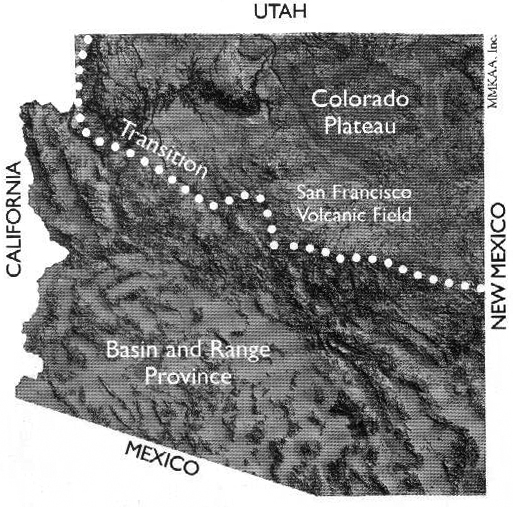
Why are Volcanoes Here? Most volcanoes are found along tectonic plate boundaries where continents and seafloors collide or move apart. We are far from a plate boundary; consequently, geologists debate why volcanoes occur here. One theory proposes that the North American plate is moving over a stationary “hot spot.” But this theory does not explain why there are young volcanic fields all along the southern margin of the Colorado Plateau and then east to New Mexico and Oklahoma.
Another more accepted theory focuses on a disruption in the flow of Earth’s mantle at the boundary between the Colorado Plateau, where the Earth’s crust is very thick, and the Basin and Range region (to the south and west), where the crust is very thin. At this transition, heat from the mantle rises and melting occurs. Ancient faults, activated by stretching of the North American plate (which has created the Basin and range and is extending into the Colorado Plateau), serve as pathways for magma to move to the surface.
Most volcanoes are found along tectonic plate boundaries where continents and seafloors collide or move apart. We are far from a plate boundary; consequently, geologists debate why volcanoes occur here. One theory proposes that the North American plate is moving over a stationary “hot spot.” But this theory does not explain why there are young volcanic fields all along the southern margin of the Colorado Plateau and then east to New Mexico and Oklahoma.
Another more accepted theory focuses on a disruption in the flow of Earth’s mantle at the boundary between the Colorado Plateau, where the Earth’s crust is very thick, and the Basin and Range region (to the south and west), where the crust is very thin. At this transition, heat from the mantle rises and melting occurs. Ancient faults, activated by stretching of the North American plate (which has created the Basin and range and is extending into the Colorado Plateau), serve as pathways for magma to move to the surface.
 Subject: Looking toward the San Simone Valley through Simone Valley, from Bonita Canyon Highway, Chi...") Whitetail Canyon
Whitetail Canyon
Subject: Looking toward the San Simone Valley through Simone Valley, from Bonita Canyon Highway, Chiricahua National Monument. Date: February 12, 1941 Collection: WACC: Chiricahua.") Volcanoes
Volcanoes Subject: General view looking west from the rim, Chiricahua National Monument.
Date: 1932
Coll...") View from the Rim
View from the Rim
Subject: General view looking west from the rim, Chiricahua National Monument. Date: 1932 Collection: WACC: Chiricahua. Subject: Looking west from the rim, Chiricahua National Monument.
Date: 1932
Collection: WACC:...") View from the Rim
View from the Rim
Subject: Looking west from the rim, Chiricahua National Monument. Date: 1932 Collection: WACC: Chiricahua. Subject: View south from Massai Point, Chiricahua National Monument.
Date: April, 1940
Collect...") View from Massai Point
View from Massai Point
Subject: View south from Massai Point, Chiricahua National Monument. Date: April, 1940 Collection: WACC: Chiricahua. Subject: Looking south from Massai Point, Chiricahua National Monument.
Date: February 12, 1941
...") View from Massai Point
View from Massai Point
Subject: Looking south from Massai Point, Chiricahua National Monument. Date: February 12, 1941 Collection: WACC: Chiricahua. Subject: View from Echo Canyon Trail, Chiricahua National Monument. Pictured: Custodian Fish and Nat...") View from Echo Canyon Trail
View from Echo Canyon Trail
Subject: View from Echo Canyon Trail, Chiricahua National Monument. Pictured: Custodian Fish and Nattalie Dodge. Date: May 27, 1938 Collection: WACC: Chiricahua. Subject: The valley viewed from the east. Stark Cabin is visible in the right foreground.
Date: U...") Valley from the East
Valley from the East
Subject: The valley viewed from the east. Stark Cabin is visible in the right foreground. Date: Unknown Collection: WACC: Chiricahua. Beneath the lava you now stand on are perhaps dozens of caves. As lava flowed, the top surface cool...") Undercurrents
Undercurrents Beneath the lava you now stand on are perhaps dozens of caves. As lava flowed, the top surface cooled first due to contact with air. A hardened crust formed. Meanwhile, rivers of lava continued flowing below, periodically breaking through the crust to form the spatter cones you saw earlier. When the flows ceased, the remaining lava drained out the downhill end of the crusted-over channels, leaving behind tube-like caves.
Most of these caves were sealed with hardened lava and have no openings to the surface. A collapse created the opening you see here.
Beneath the lava you now stand on are perhaps dozens of caves. As lava flowed, the top surface cooled first due to contact with air. A hardened crust formed. Meanwhile, rivers of lava continued flowing below, periodically breaking through the crust to form the spatter cones you saw earlier. When the flows ceased, the remaining lava drained out the downhill end of the crusted-over channels, leaving behind tube-like caves.
Most of these caves were sealed with hardened lava and have no openings to the surface. A collapse created the opening you see here.

 Description: Dendrochronology sample from a Douglass Fir dating from the pith at A.D. 1013 to the ou...") Tree-ring Sample
Tree-ring Sample
Description: Dendrochronology sample from a Douglass Fir dating from the pith at A.D. 1013 to the outside ring at A.D. 1120. The ring marked "1064" is the most commonly accepted date for the eruption of the Sunset Crater volcano. Dimensions: 6.75 in (L), 1 in (Th). Collection: On display at the Sunset Crater Volcano National Monument Visitor Center (catalog card). The ancestors of today’s Hopi and Zuni Indians witnessed the eruption.
In some Hopi accounts, t...") Traditions
Traditions
The ancestors of today’s Hopi and Zuni Indians witnessed the eruption. In some Hopi accounts, the Qa’na Katsina caused Palatsmo (Sunset Crater) to erupt after people engaged koyaanisqatsi, a life out of balance. For Hopi people, Palatsmo is a living reminder: if people stray from their religious ideals and lifeway, there may be another eruption. In Zuni traditions, stories of the eruption were carefully guarded because of the belief if people continually dwell upon negative events those events will happen.
Regardless of our worldview, places like Sunset Crater Volcano National Monument help us to better understand each other and the forces that continually affect our lives. Subject: Tolson party on Bonita Canyon Highway, Chiricahua National Monument.
Date: April, 1935
...") Tolson Party
Tolson Party
Subject: Tolson party on Bonita Canyon Highway, Chiricahua National Monument. Date: April, 1935 Collection: WACC: Chiricahua. Subject: View of the main house from the southern orchard.
Date: Unknown
Collection: WACC: Chi...") The Main House, Viewed from the Orchard
The Main House, Viewed from the Orchard
Subject: View of the main house from the southern orchard. Date: Unknown Collection: WACC: Chiricahua.