 round trip.
Time required: 45 minutes
Terrain: Paved with some steps and inclines. Wheelchair accessible to overlook, beyond with assistance.
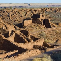
The farming settlement of Wupatki was unique. To appreciate why, we have to start by thinking big. From roughly 400 to 1700, culture in the Southwest was distinguished by farming, pottery, villages, seasonal moves, and large scale migrations. Major settlement systems were in place by 1100 in Chaco Canyon, the Phoenix Basin, and northern Mesoamerica. With favorable climates for agriculture and room to grow, the Southwest's farming population was reaching a peak.
Until the mid-1100s, Wupatki remained a frontier between established groups, defined by archeologists as Sinagua, Cohonina, and Kayenta. Then, in one of the warmest, driest places on the Colorado Plateau, life flourished. This became a densely populated landscape supporting a complex society where people, goods, and ideas converged.")
Length: 1/2 mile (0.8 km) round trip.
Time required: 45 minutes
Terrain: Paved with some steps and inclines. Wheelchair accessible to overlook, beyond with assistance.
The farming settlement of Wupatki was unique. To appreciate why, we have to start by thinking big. From roughly 400 to 1700, culture in the Southwest was distinguished by farming, pottery, villages, seasonal moves, and large scale migrations. Major settlement systems were in place by 1100 in Chaco Canyon, the Phoenix Basin, and northern Mesoamerica. With favorable climates for agriculture and room to grow, the Southwest's farming population was reaching a peak.
Until the mid-1100s, Wupatki remained a "frontier" between established groups, defined by archeologists as Sinagua, Cohonina, and Kayenta. Then, in one of the warmest, driest places on the Colorado Plateau, life flourished. This became a densely populated landscape supporting a complex society where people, goods, and ideas converged.
- Author
- Dan Boone/Ryan Belnap, Bilby Research Center, Northern Arizona University
- File
- wupatki_pueblo.jpg
- File size
- 116 KB