Home / National Park Service Exhibits / Wupatki National Monument (WUPA) / Sites / Wupatki Pueblo Virtual Trail Guide 27
Wupatki Pueblo is the largest pueblo in Wupatki National Monument. The pueblo contained more than 100 rooms, a community room or kiva, and a ballcourt. This virtual trail guide mimics the paper trail guide and benchmarks you would experience in person when walking the trail at Wupatki Pueblo. The text derives directly from the Wupatki Pueblo Trail Guide currently used by the National Park Service at Wupatki National Monument.
Knowledgeable Hopis feel the proper place name for this area in Nuvaovi (the place of the snow) and the site known today as Wukoki was Wupatki.
Knowledgeable Hopis feel the proper place name for this area in Nuvaovi (the place of the snow) and the site known today as Wukoki was Wupatki.

 Length: 1/2 mile (0.8 km) round trip.
Time required: 45 minutes
Terrain: Paved with some steps a...") Introduction to the Trail
Introduction to the Trail
Length: 1/2 mile (0.8 km) round trip. Time required: 45 minutes Terrain: Paved with some steps and inclines. Wheelchair accessible to overlook, beyond with assistance.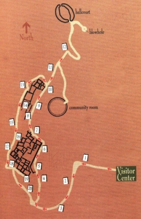
The farming settlement of Wupatki was unique. To appreciate why, we have to start by thinking big. From roughly 400 to 1700, culture in the Southwest was distinguished by farming, pottery, villages, seasonal moves, and large scale migrations. Major settlement systems were in place by 1100 in Chaco Canyon, the Phoenix Basin, and northern Mesoamerica. With favorable climates for agriculture and room to grow, the Southwest's farming population was reaching a peak. Until the mid-1100s, Wupatki remained a "frontier" between established groups, defined by archeologists as Sinagua, Cohonina, and Kayenta. Then, in one of the warmest, driest places on the Colorado Plateau, life flourished. This became a densely populated landscape supporting a complex society where people, goods, and ideas converged.
\"For its time and place there was no other pueblo like Wupatki. It was in all probability the tal...") Wupatki Pueblo and Surrounding Features
Wupatki Pueblo and Surrounding Features "For its time and place there was no other pueblo like Wupatki. It was in all probability the tallest, largest, and perhaps the richest and most influential pueblo in the area."
-E. Brennan and C. Downum, from Report of Findings Prestabilization Documentation for Wupatki Pueblo
"For its time and place there was no other pueblo like Wupatki. It was in all probability the tallest, largest, and perhaps the richest and most influential pueblo in the area."
-E. Brennan and C. Downum, from Report of Findings Prestabilization Documentation for Wupatki Pueblo
People gathered here during the 1100s and what began as family housing grew into this 100-room pueblo with a tower, community room, and ceremonial ballcourt. Located near the crossroads of east-west and north-south travel routes, the pueblo evolved to serve a community heavily engaged not only in farming but also in ceremony, trade, and crafts specialization. By 1190, as many as 2,000 people lived within a day's walk and Wupatki Pueblo was the largest building for at least 50 miles. Archaeologists are challenged to define a cultural identity for Wupatki Pueblo with its intriguing blend of Kayenta and Sinagua architectural styles and more than 100 pottery types. The name Wupatki derives from Hopi words that translate literally into \"it was cut long,\" and recall...") Overlook Interpretative Panel
Overlook Interpretative Panel
The name Wupatki derives from Hopi words that translate literally into "it was cut long," and recalls an event in the histories of the Hopi clans. It is said that people prospered here. In time men began gambling and ignored their crops and prayers for rain. Concerned, their leader severed a ritual object and then went into exile. When he returned the people awoke from their decadence. For today's Hopi people, the villages of Wupatki remain among the most important \"footprints\" of the...") Overlook Interpretative Panel
Overlook Interpretative Panel
For today's Hopi people, the villages of Wupatki remain among the most important "footprints" of the ancestral clans. It was on this landscape, in the shadow of the San Francisco Peaks, that a number of migrating clans met and merged. Significant events, and new traditions and ceremonies resulted. The Zuni and other Puebloan groups (Acoma, Laguna, and Rio Grande) share Wupatki's history as they share a belief in a common origin that begins with their ancestors. Stories of Wupatki also exist among non-Puebloan groups (Havasupai, Yavapai, Hualapai, Southern Paiute, and Navajo) whose ancestors interacted with Puebloan ancestors. The dates for these interactions are unknown.
A curious place to build a farming community...summers are hot, dry and windy. Yet 800 years ago,...") Living and Storage Rooms
Living and Storage Rooms A curious place to build a farming community...summers are hot, dry and windy. Yet 800 years ago, agricultural plots would have dotted the landscape, carefully placed in scant pockets of soil.
A farmer's faith was tested regularly as rainfall came at the wrong time or not at all, and dry winds parched the soil and crops. Each field was at the mercy of where rain fell; no surface irrigation was possible. One field might produce while another withered, so the planting effort was extensive.
Then, as now, water was limited. Across the area, a few seeps and springs existed; catchments held water for a time, and the Little Colorado River provided a seasonal water source.
Still the abundance of storage pots suggests water had to be acquired and managed to be available when needed. Perhaps, as Hopi believe, people derived strength from this challenging land.
A curious place to build a farming community...summers are hot, dry and windy. Yet 800 years ago, agricultural plots would have dotted the landscape, carefully placed in scant pockets of soil.
A farmer's faith was tested regularly as rainfall came at the wrong time or not at all, and dry winds parched the soil and crops. Each field was at the mercy of where rain fell; no surface irrigation was possible. One field might produce while another withered, so the planting effort was extensive.
Then, as now, water was limited. Across the area, a few seeps and springs existed; catchments held water for a time, and the Little Colorado River provided a seasonal water source.
Still the abundance of storage pots suggests water had to be acquired and managed to be available when needed. Perhaps, as Hopi believe, people derived strength from this challenging land.
The black cinders blanketing the ground remain from the eruption of nearby Sunset Crater volcano s...") Sunset Crater and Wupatki
Sunset Crater and Wupatki The black cinders blanketing the ground remain from the eruption of nearby Sunset Crater volcano some time between 1040 and 1100. The settlement of Wupatki followed but it's uncertain if there was a direct cause and effect.
People may have been drawn by the eruption and stayed. Or, perhaps those displaced by the eruption moved to this lower elevation. However, as many as three generations may have passed before anyone decided to live here.
We do know that ash from the eruption, in a thin uniform layer, retained precious soil moisture providing a window of improved farming potential in this semi-arid landscape.
The black cinders blanketing the ground remain from the eruption of nearby Sunset Crater volcano some time between 1040 and 1100. The settlement of Wupatki followed but it's uncertain if there was a direct cause and effect.
People may have been drawn by the eruption and stayed. Or, perhaps those displaced by the eruption moved to this lower elevation. However, as many as three generations may have passed before anyone decided to live here.
We do know that ash from the eruption, in a thin uniform layer, retained precious soil moisture providing a window of improved farming potential in this semi-arid landscape. Notice how people shaped their lives to this land. Sun, water, wind, and earth influenced decisions...") Terraced Rooms
Terraced Rooms
Notice how people shaped their lives to this land. Sun, water, wind, and earth influenced decisions. Using the red sandstone outcrop as a backbone, and its naturally fractured blocks as bricks, masons laid stone rooms up and down the length of the formation. High walls on the north and west sides blunted prevailing winds. Terraced rooms to the south and east bathed in winter sun. Flat roofs served as water systems, collecting precipitation and directing it to storage pots. Wupatki Pueblo stood three stories high in places. Double walls were filled with a rubble core and were about 6 feet (2 meters) high; roofs were constructed with timbers, cross-laid with smaller beams or reeds, and finished with grass and mud. There were no exterior doorways at ground level.
Built out in the open, Wupatki is far more typical of 12th century structures than a cliff dwelling. Cliff dwellings make up only a fraction of known southwestern archeological sites.
Wupatki Pueblo stood three stories high in places. Double walls were filled with a rubble core and were about 6 feet (2 meters) high; roofs were constructed with timbers, cross-laid with smaller beams or reeds, and finished with grass and mud. There were no exterior doorways at ground level.
Built out in the open, Wupatki is far more typical of 12th century structures than a cliff dwelling. Cliff dwellings make up only a fraction of known southwestern archeological sites.
"...The family, the dwelling house and the field are inseparable, because the woman is the heart of these, and they rest with her... The man builds the house but the woman is the owner, because she repairs and preserves it." -A Hopi view of the community, presented to "the Washington Chiefs," 1894
Compare the images above. The rooms now visible were buried beneath rubble cleared during excavat...") Wupatki Pueblo 1930s vs. 2011
Wupatki Pueblo 1930s vs. 2011 Compare the images above. The rooms now visible were buried beneath rubble cleared during excavation beginning in 1933.
When occupied, this mud and stone building would have required periodic maintenance. Once people departed, natural forces prevailed - mortar eroded, roofs collapsed, walls tumbled. What you see today is an excavated building, heavily stabilized to postpone deterioration. The modern iron beam and plate visible here support the upper walls. The low walls exhibit Portland cement, used from the 1930s to 60s, and new stabilization mortars that more closely duplicate original materials. Although walls stand in their original location, virtually all the mortar you see is modern. Stabilization has compromised the historical architecture, but helps an excavated building withstand natural and human-induced erosion.
You are one of hundreds of thousands of visitors - please, do not lean, sit, or walk on any walls.
Numerous storage rooms within the pueblo attest to a constant preparedness for crop failure. Peop...") Storage and Food Processing
Storage and Food Processing Numerous storage rooms within the pueblo attest to a constant preparedness for crop failure. People likely had some of last year's corn on hand at this year's harvest. Perhaps this room served for storage and food processing.
Imagine corn stacked like cordwood, or gathered foods such as piñon nuts, rice grass seeds, and juniper berries secured in clay seed jars. Water jars undoubtedly sat here too. Hours spent at these grinding stones reduced corn and seeds to flour.
Numerous storage rooms within the pueblo attest to a constant preparedness for crop failure. People likely had some of last year's corn on hand at this year's harvest. Perhaps this room served for storage and food processing.
Imagine corn stacked like cordwood, or gathered foods such as piñon nuts, rice grass seeds, and juniper berries secured in clay seed jars. Water jars undoubtedly sat here too. Hours spent at these grinding stones reduced corn and seeds to flour.
In this room, someone designed an innovative air circulation system to allow for an indoor fire. A...") Air Circulation System
Air Circulation System In this room, someone designed an innovative air circulation system to allow for an indoor fire. A stone-lined ventilator trench is connected to an opening in the base of the cliff wall.
The upright stone slab at the end of the ventilator trench deflected incoming air so that the draft would pass directly across the firepit. Smoke would exit through a roof opening.
Note how preservation efforts have changed this building: original floor surface, as with this room, are much lower - dirt placed in the rooms after excavation protects floor features and keeps walls from collapsing.
Throughout the dwelling you'll see a variety of modern drains that keep water from standing in rooms. In some cases the architecture has been altered. For example, the square and round holes on this front wall were placed for drainage, and the large masonry column built in the back corner supports the upper wall.
In this room, someone designed an innovative air circulation system to allow for an indoor fire. A stone-lined ventilator trench is connected to an opening in the base of the cliff wall.
The upright stone slab at the end of the ventilator trench deflected incoming air so that the draft would pass directly across the firepit. Smoke would exit through a roof opening.
Note how preservation efforts have changed this building: original floor surface, as with this room, are much lower - dirt placed in the rooms after excavation protects floor features and keeps walls from collapsing.
Throughout the dwelling you'll see a variety of modern drains that keep water from standing in rooms. In some cases the architecture has been altered. For example, the square and round holes on this front wall were placed for drainage, and the large masonry column built in the back corner supports the upper wall.
This section of the pueblo remains unexcavated. These rooms represent an opportunity to learn mor...") Unexcavated Rooms
Unexcavated Rooms This section of the pueblo remains unexcavated. These rooms represent an opportunity to learn more about the past, but the knowledge comes at a cost. Excavation disturbs the site, and potentially, the people and artifacts buried there. Collected materials require elaborate conservation and storage methods; in the ground, this arid climate preserves artifacts almost indefinitely, free of charge.
In the past, few people challenged the purposes of archaeological investigation, but today many voice concerns about disturbing sites. Should rooms be excavated, unearthing pots and other items? Possessions were intended, by those who buried or left them behind, to remain as placed, acted upon by time and the elements. Excavation represents a curiosity foreign to American Indian culture and often considered culturally offensive. Do objects from the past serve as legitimate educational tools, or is that notion unimportant or even wrong?
This section of the pueblo remains unexcavated. These rooms represent an opportunity to learn more about the past, but the knowledge comes at a cost. Excavation disturbs the site, and potentially, the people and artifacts buried there. Collected materials require elaborate conservation and storage methods; in the ground, this arid climate preserves artifacts almost indefinitely, free of charge.
In the past, few people challenged the purposes of archaeological investigation, but today many voice concerns about disturbing sites. Should rooms be excavated, unearthing pots and other items? Possessions were intended, by those who buried or left them behind, to remain as placed, acted upon by time and the elements. Excavation represents a curiosity foreign to American Indian culture and often considered culturally offensive. Do objects from the past serve as legitimate educational tools, or is that notion unimportant or even wrong?
The reconstructed circular structure below you resembles a great kiva, a special room used for rit...") Community Room
Community Room The reconstructed circular structure below you resembles a great kiva, a special room used for rituals and ceremonies. However, excavators found no evidence of a roof or other floor features typical of a kiva. Archeologists speculate that this open-air community room could have served as a central gathering place. Imagine voices carrying to others assembled on the pueblo roof tops.
People may have come from nearby and distant villages to participate in ceremonies held here. Maybe rituals focused the community and solved problems, or served to redistribute materials and food.
The reconstructed circular structure below you resembles a great kiva, a special room used for rituals and ceremonies. However, excavators found no evidence of a roof or other floor features typical of a kiva. Archeologists speculate that this open-air community room could have served as a central gathering place. Imagine voices carrying to others assembled on the pueblo roof tops.
People may have come from nearby and distant villages to participate in ceremonies held here. Maybe rituals focused the community and solved problems, or served to redistribute materials and food.
Other people have come and gone since the original occupants. During the late 1800s, Basque sheep...") Room 73, 1930s vs. 2011
Room 73, 1930s vs. 2011 Other people have come and gone since the original occupants. During the late 1800s, Basque sheepherders stayed here briefly, enlarging this doorway and occupying the room beyond. Local prospector Ben Doney pothunted Wupatki, amassing an impressive collection of artifacts.
Concern over looting at Wupatki led to its protection as a national monument in 1924. Later expansion of the monument included some land historically used since the mid-1800s by Navajo naat' áanii (headman) Peshlakai Etsidi and his descendants. These Diné families grazed sheep here, moving seasonally between numerous camps, leaving behind more than 60 residential sites. Their history is intertwined with that of the monument. They remain intimately tied to the Wupatki landscape.
Other people have come and gone since the original occupants. During the late 1800s, Basque sheepherders stayed here briefly, enlarging this doorway and occupying the room beyond. Local prospector Ben Doney pothunted Wupatki, amassing an impressive collection of artifacts.
Concern over looting at Wupatki led to its protection as a national monument in 1924. Later expansion of the monument included some land historically used since the mid-1800s by Navajo naat' áanii (headman) Peshlakai Etsidi and his descendants. These Diné families grazed sheep here, moving seasonally between numerous camps, leaving behind more than 60 residential sites. Their history is intertwined with that of the monument. They remain intimately tied to the Wupatki landscape.
Rooms on this end of the pueblo were excavated and reconstructed to serve as an office and museum. The National Park Service now has a policy of stabilizing buildings in their existing state. The 1930s reconstructions were removed in 1950.
The extent of this community is not obvious, but hundreds of small family dwellings surround us fo...") Nearby Homes
Nearby Homes The extent of this community is not obvious, but hundreds of small family dwellings surround us forming a cluster. Another cluster exists on the uplands to the west (where you may visit Citadel and Lomaki Pueblos). We don't know if the Wupatki and Citadel communities were autonomous, cooperatives, or competitors.
From this point, you can see two other nearby homes. These sites are not open to visitation.
The extent of this community is not obvious, but hundreds of small family dwellings surround us forming a cluster. Another cluster exists on the uplands to the west (where you may visit Citadel and Lomaki Pueblos). We don't know if the Wupatki and Citadel communities were autonomous, cooperatives, or competitors.
From this point, you can see two other nearby homes. These sites are not open to visitation.
"We found... all the prominent points occupied by the ruins of stone houses of considerable size... They are evidently the remains of a large town, as they occurred at intervals for an extent of eight or nine miles and the ground was thickly strewed with pottery in all directions." -Journal entry, Sitgreaves Expedition, October 8, 1851
The reconstructed ballcourt was an unusual structure. Known ballcourts in the Southwest were not ...") Ballcourt
Ballcourt The reconstructed ballcourt was an unusual structure. Known ballcourts in the Southwest were not masonry. This court may have had multiple functions: a place where special ceremonies were held, where competitive games took place for socialization, or where children played a game of stick and ball, similar to hockey. After rains, it may have served as a reservoir.
Some archaeologists think valuables changed hands through ritual events such as ball games. People living to the south (Hohokam tradition) had shells, salt, cotton, and a ballcourt in every town. People to the east in the Chaco region (Ancestral Puebloan tradition) has Mesoamerican macaws, copper, and turquoise to trade. A ballcourt at Wupatki could function as a link between distant regions. Trade valuables from both regions ended up here.
Sandals trod far and wide, maintaining trade networks that helped meet mutual needs and improved the quality of life. When materials, innovations, and ideas came to communities, all knew what others had to offer.
The reconstructed ballcourt was an unusual structure. Known ballcourts in the Southwest were not masonry. This court may have had multiple functions: a place where special ceremonies were held, where competitive games took place for socialization, or where children played a game of stick and ball, similar to hockey. After rains, it may have served as a reservoir.
Some archaeologists think valuables changed hands through ritual events such as ball games. People living to the south (Hohokam tradition) had shells, salt, cotton, and a ballcourt in every town. People to the east in the Chaco region (Ancestral Puebloan tradition) has Mesoamerican macaws, copper, and turquoise to trade. A ballcourt at Wupatki could function as a link between distant regions. Trade valuables from both regions ended up here.
Sandals trod far and wide, maintaining trade networks that helped meet mutual needs and improved the quality of life. When materials, innovations, and ideas came to communities, all knew what others had to offer.