Home / Search results 33
Choose filters
Cancel
Validate
Choose filters
Validate
Validate
Validate


The reconstructed circular structure below you resembles a great kiva, a special room used for rit...") Community Room
Community Room The reconstructed circular structure below you resembles a great kiva, a special room used for rituals and ceremonies. However, excavators found no evidence of a roof or other floor features typical of a kiva. Archeologists speculate that this open-air community room could have served as a central gathering place. Imagine voices carrying to others assembled on the pueblo roof tops.
People may have come from nearby and distant villages to participate in ceremonies held here. Maybe rituals focused the community and solved problems, or served to redistribute materials and food.
The reconstructed circular structure below you resembles a great kiva, a special room used for rituals and ceremonies. However, excavators found no evidence of a roof or other floor features typical of a kiva. Archeologists speculate that this open-air community room could have served as a central gathering place. Imagine voices carrying to others assembled on the pueblo roof tops.
People may have come from nearby and distant villages to participate in ceremonies held here. Maybe rituals focused the community and solved problems, or served to redistribute materials and food. Location: Crack-in-Rock Pueblo, Wupatki National Monument.") Door at Crack-in-Rock Pueblo
Door at Crack-in-Rock Pueblo
Location: Crack-in-Rock Pueblo, Wupatki National Monument. Notice how people shaped their lives to this land. Sun, water, wind, and earth influenced decisions...") Terraced Rooms
Terraced Rooms
Notice how people shaped their lives to this land. Sun, water, wind, and earth influenced decisions. Using the red sandstone outcrop as a backbone, and its naturally fractured blocks as bricks, masons laid stone rooms up and down the length of the formation. High walls on the north and west sides blunted prevailing winds. Terraced rooms to the south and east bathed in winter sun. Flat roofs served as water systems, collecting precipitation and directing it to storage pots. Wupatki Pueblo stood three stories high in places. Double walls were filled with a rubble core and were about 6 feet (2 meters) high; roofs were constructed with timbers, cross-laid with smaller beams or reeds, and finished with grass and mud. There were no exterior doorways at ground level.
Built out in the open, Wupatki is far more typical of 12th century structures than a cliff dwelling. Cliff dwellings make up only a fraction of known southwestern archeological sites.
Wupatki Pueblo stood three stories high in places. Double walls were filled with a rubble core and were about 6 feet (2 meters) high; roofs were constructed with timbers, cross-laid with smaller beams or reeds, and finished with grass and mud. There were no exterior doorways at ground level.
Built out in the open, Wupatki is far more typical of 12th century structures than a cliff dwelling. Cliff dwellings make up only a fraction of known southwestern archeological sites.
"...The family, the dwelling house and the field are inseparable, because the woman is the heart of these, and they rest with her... The man builds the house but the woman is the owner, because she repairs and preserves it." -A Hopi view of the community, presented to "the Washington Chiefs," 1894 Length: 1/2 mile (0.8 km) round trip.
Time required: 45 minutes
Terrain: Paved with some steps a...") Introduction to the Trail
Introduction to the Trail
Length: 1/2 mile (0.8 km) round trip. Time required: 45 minutes Terrain: Paved with some steps and inclines. Wheelchair accessible to overlook, beyond with assistance.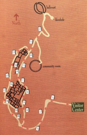
The farming settlement of Wupatki was unique. To appreciate why, we have to start by thinking big. From roughly 400 to 1700, culture in the Southwest was distinguished by farming, pottery, villages, seasonal moves, and large scale migrations. Major settlement systems were in place by 1100 in Chaco Canyon, the Phoenix Basin, and northern Mesoamerica. With favorable climates for agriculture and room to grow, the Southwest's farming population was reaching a peak. Until the mid-1100s, Wupatki remained a "frontier" between established groups, defined by archeologists as Sinagua, Cohonina, and Kayenta. Then, in one of the warmest, driest places on the Colorado Plateau, life flourished. This became a densely populated landscape supporting a complex society where people, goods, and ideas converged. Villages like Wupatki were purposely settled and left for reasons we may never fully understand. Af...") Leaving Wupatki
Leaving Wupatki
Villages like Wupatki were purposely settled and left for reasons we may never fully understand. After roughly 150 years here, maybe life ceased to be good. Perhaps the rumor of a better life in another village was worth investigating. Maybe, as some Hopi believe, the people stayed too long here and failed to lead moral and responsible lives. Ensuing social and environmental catastrophes were signals to resume migrations to find and settle the place where Hopi live to this day. By 1300, across the region people had moved into villages even larger than Wupatki. Those living here joined others at places like Homol'ovi along the Little Colorado River (near present day Winslow, Arizona) or at villages south of Walnut Canyon. According to clan histories, some went directly east to the Hopi Mesas. A few undoubtedly chose to stay behind.
Today this village rests silent but not forgotten. Though it is no longer physically occupied, Hopi and Zuni people believe those who lived and died here remain as spiritual guardians. Descendants visit periodically to enrich their personal understanding of their clan histories. Wupatki is remembered and cared for, not abandoned.
By 1300, across the region people had moved into villages even larger than Wupatki. Those living here joined others at places like Homol'ovi along the Little Colorado River (near present day Winslow, Arizona) or at villages south of Walnut Canyon. According to clan histories, some went directly east to the Hopi Mesas. A few undoubtedly chose to stay behind.
Today this village rests silent but not forgotten. Though it is no longer physically occupied, Hopi and Zuni people believe those who lived and died here remain as spiritual guardians. Descendants visit periodically to enrich their personal understanding of their clan histories. Wupatki is remembered and cared for, not abandoned.
"...for us life is shrouded in mystery and the world defies explanation...humans do not need to know everything there is to be known. The human past, we feel, is a universal past. No one can claim it, and no one can ever know it completely." -Rina Swentzell, Pueblo Santa Clara
Numerous storage rooms within the pueblo attest to a constant preparedness for crop failure. Peop...") Storage and Food Processing
Storage and Food Processing Numerous storage rooms within the pueblo attest to a constant preparedness for crop failure. People likely had some of last year's corn on hand at this year's harvest. Perhaps this room served for storage and food processing.
Imagine corn stacked like cordwood, or gathered foods such as piñon nuts, rice grass seeds, and juniper berries secured in clay seed jars. Water jars undoubtedly sat here too. Hours spent at these grinding stones reduced corn and seeds to flour.
Numerous storage rooms within the pueblo attest to a constant preparedness for crop failure. People likely had some of last year's corn on hand at this year's harvest. Perhaps this room served for storage and food processing.
Imagine corn stacked like cordwood, or gathered foods such as piñon nuts, rice grass seeds, and juniper berries secured in clay seed jars. Water jars undoubtedly sat here too. Hours spent at these grinding stones reduced corn and seeds to flour.
The reconstructed ballcourt was an unusual structure. Known ballcourts in the Southwest were not ...") Ballcourt
Ballcourt The reconstructed ballcourt was an unusual structure. Known ballcourts in the Southwest were not masonry. This court may have had multiple functions: a place where special ceremonies were held, where competitive games took place for socialization, or where children played a game of stick and ball, similar to hockey. After rains, it may have served as a reservoir.
Some archaeologists think valuables changed hands through ritual events such as ball games. People living to the south (Hohokam tradition) had shells, salt, cotton, and a ballcourt in every town. People to the east in the Chaco region (Ancestral Puebloan tradition) has Mesoamerican macaws, copper, and turquoise to trade. A ballcourt at Wupatki could function as a link between distant regions. Trade valuables from both regions ended up here.
Sandals trod far and wide, maintaining trade networks that helped meet mutual needs and improved the quality of life. When materials, innovations, and ideas came to communities, all knew what others had to offer.
The reconstructed ballcourt was an unusual structure. Known ballcourts in the Southwest were not masonry. This court may have had multiple functions: a place where special ceremonies were held, where competitive games took place for socialization, or where children played a game of stick and ball, similar to hockey. After rains, it may have served as a reservoir.
Some archaeologists think valuables changed hands through ritual events such as ball games. People living to the south (Hohokam tradition) had shells, salt, cotton, and a ballcourt in every town. People to the east in the Chaco region (Ancestral Puebloan tradition) has Mesoamerican macaws, copper, and turquoise to trade. A ballcourt at Wupatki could function as a link between distant regions. Trade valuables from both regions ended up here.
Sandals trod far and wide, maintaining trade networks that helped meet mutual needs and improved the quality of life. When materials, innovations, and ideas came to communities, all knew what others had to offer. Park rangers once lived in this pueblo. The two rooms above were reconstructed to house employees J...") Reconstructed Rooms, 1930s vs. 2011
Reconstructed Rooms, 1930s vs. 2011
Park rangers once lived in this pueblo. The two rooms above were reconstructed to house employees Jimmy and Sallie Brewer, and Davy and Corky Jones during the 1930s. They hauled water from the nearby spring, but had the luxury of cooking with propane. Jones excavated a small adjoining storage room to house a gas refrigerator; commercial electricity did not arrive until 1959. The government, of course, charged them rent - $10 per month! "Those were the two rooms we were to live in. At the top of the ladder was the room used as a bedroom and office, and (to the right) the beautiful sunny little kitchen. The water was in a barrel behind a niche in the kitchen wall... Davy pumped the water in once a week, fifty-five gallons, and that sufficed for everything. We took our baths there unless it was a special occasion, when we would go down to where the spring ran out to the sheep troughs. There was more water that way, but there were apt to be sheep and Navajos, too." -Corky Jones, from Letters from Wupatki
Reconstructed rooms may help us to visualize the past and identify more closely with the inhabitants. But, the mental images we construct and conclusions we draw likely mirror our present rather than reflect the world in which they lived. Reconstructions lead us to believe we know the past, when in reality, so much will never be known. Like other reconstructions, these walls and roofs were removed in the 1950s. Location: Box Canyon, Wupatki National Monument.
Description: Moenkopi sandstone and Kaibab limes...") Lomaki Area Ruin
Lomaki Area Ruin
Location: Box Canyon, Wupatki National Monument. Description: Moenkopi sandstone and Kaibab limestone masonry structure on the Lomaki/Box Canyon Pueblos trail in Wupatki National Monument. Location: Wukoki Pueblo, Wupatki National Monument.
Description: Wukoki on a hot summer day.") Wukoki
Wukoki
Location: Wukoki Pueblo, Wupatki National Monument. Description: Wukoki on a hot summer day. Location: Wukoki Pueblo, Wupatki National Monument.
Description: The landscape surrounding Wukoki...") Summer Monsoon, Wukoki
Summer Monsoon, Wukoki
Location: Wukoki Pueblo, Wupatki National Monument. Description: The landscape surrounding Wukoki during summer monsoons. Location: Wukoki, Wupatki National Monument. The pueblo was built and occupied between A.D. 1120 an...") Wukoki Pueblo
Wukoki Pueblo
Location: Wukoki, Wupatki National Monument. The pueblo was built and occupied between A.D. 1120 and A.D. 1210. Location: Citadel, Wupatki National Monument.
Description: Isolated summer monsoon just north of ...") Summer Monsoon, Citadel Ruin
Summer Monsoon, Citadel Ruin
Location: Citadel, Wupatki National Monument. Description: Isolated summer monsoon just north of the San Francisco Peaks, as viewed from Citadel Ruin.
\"For its time and place there was no other pueblo like Wupatki. It was in all probability the tal...") Wupatki Pueblo and Surrounding Features
Wupatki Pueblo and Surrounding Features "For its time and place there was no other pueblo like Wupatki. It was in all probability the tallest, largest, and perhaps the richest and most influential pueblo in the area."
-E. Brennan and C. Downum, from Report of Findings Prestabilization Documentation for Wupatki Pueblo
"For its time and place there was no other pueblo like Wupatki. It was in all probability the tallest, largest, and perhaps the richest and most influential pueblo in the area."
-E. Brennan and C. Downum, from Report of Findings Prestabilization Documentation for Wupatki Pueblo
People gathered here during the 1100s and what began as family housing grew into this 100-room pueblo with a tower, community room, and ceremonial ballcourt. Located near the crossroads of east-west and north-south travel routes, the pueblo evolved to serve a community heavily engaged not only in farming but also in ceremony, trade, and crafts specialization. By 1190, as many as 2,000 people lived within a day's walk and Wupatki Pueblo was the largest building for at least 50 miles. Archaeologists are challenged to define a cultural identity for Wupatki Pueblo with its intriguing blend of Kayenta and Sinagua architectural styles and more than 100 pottery types.
A curious place to build a farming community...summers are hot, dry and windy. Yet 800 years ago,...") Living and Storage Rooms
Living and Storage Rooms A curious place to build a farming community...summers are hot, dry and windy. Yet 800 years ago, agricultural plots would have dotted the landscape, carefully placed in scant pockets of soil.
A farmer's faith was tested regularly as rainfall came at the wrong time or not at all, and dry winds parched the soil and crops. Each field was at the mercy of where rain fell; no surface irrigation was possible. One field might produce while another withered, so the planting effort was extensive.
Then, as now, water was limited. Across the area, a few seeps and springs existed; catchments held water for a time, and the Little Colorado River provided a seasonal water source.
Still the abundance of storage pots suggests water had to be acquired and managed to be available when needed. Perhaps, as Hopi believe, people derived strength from this challenging land.
A curious place to build a farming community...summers are hot, dry and windy. Yet 800 years ago, agricultural plots would have dotted the landscape, carefully placed in scant pockets of soil.
A farmer's faith was tested regularly as rainfall came at the wrong time or not at all, and dry winds parched the soil and crops. Each field was at the mercy of where rain fell; no surface irrigation was possible. One field might produce while another withered, so the planting effort was extensive.
Then, as now, water was limited. Across the area, a few seeps and springs existed; catchments held water for a time, and the Little Colorado River provided a seasonal water source.
Still the abundance of storage pots suggests water had to be acquired and managed to be available when needed. Perhaps, as Hopi believe, people derived strength from this challenging land.