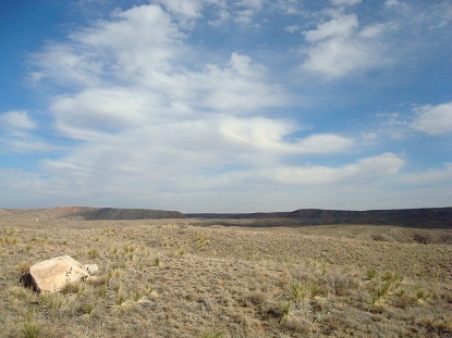
The Llano Estacado. Photo Credit: National Park Service.
The Southern High Plains, or Llano Estacado (staked plain), are the portion of the High Plains south of the Canadian River in eastern New Mexico and in the western panhandles of Texas and Oklahoma. The Southern High Plains are bounded on the east by the Caprock escarpment and on the west by the Mescalero escarpment, and the southern boundary in Texas, the Southern High Plaines grade into Edwards Plateau.
Area: The Llano Estacado comprises roughly 97,000 sq km (37,500 sq mi).
Precipitation: The eastern Llano Estacado average is 58 cm (23 in) per year. The northwest portion of Edwards Plateau (the southern margin of the Llano Estacado) receives as little as 38 cm (15 in) in a year. Most of the precipitation the Southern High Plains does receive is lost to evaporation.
Temperature: Summer temperatures above 85 degrees F are not uncommon, nor is snow in the winter.
Elevation: The Llano Estacado ranges between 900 meters (3,000 ft) and 1,525 meters (5,000 ft).
Life Zones: Upper Sonoran
Vegetation: The Southern High Plains are largely treeless. The majority of the Llano Estacado is short grass prairie dominated by buffalo grass. To the west, the Llano Estacado is more of a mid-grass prairie, Creosote bush is common on the southern portion of the Llano Estacado, and along shallow canyon floors, mesquite, cottonwood, juniper, and sumac are also supported. Likewise, the playa lakes of the Southern High Plains create their own microenvironments
Geology: The Llano Estacado is a plateau bounded on the north, east, and west, by cliffs. The underlying stone of the Llano Estacado is Ogallala Formation limestone capped with caliche. The caliche is the result of both water and wind, which have also formed sinks and depressions, or playas, in the surface of the stone.
Prehistoric Cultures: Paleoindian, Ancestral Puebloan, and the Central Plains Tradition.
National Parks: Lake Meredith and Alibates Flint Quarry.